Travel and navigation
If you can't tell the players without a
program, you'll find travel far more difficult without a map. I
discuss common map products, then provide a listing of where and how
to obtain free or low cost map products for your use. I'll cover
compasses, and point you to free, on-line training sources for the
use of your compass. While a GPS receiver is nice, it does have some
real-world drawbacks - I'll discuss those drawbacks.
Just like at the ball field, if you can't tell the players without a program, you may soon get lost if you lack a map to keep you on track. So, let's start this discussion with - why have a map in your DIY disaster kit? Simple, you need one.
Why Maps?
If you're like most folks I know, you
have a favorite route to get places. If asked to give directions, I
suspect you'll use phrases like, "Turn at the gas station"
or "Go two blocks past the school, then turn right." You
drive or travel places everyday - to work, the grocery store, to see
friends and even over the river and though the woods to visit
grandmother. And for your everyday needs, it works great.
What happens, though, when the river
overflows its banks and wipes out the bridge you always use? Where
is the next bridge up or downstream? Is a ferry available? How do
you even get to the next bridge? Where are the low spots most
likely to get flooded when the river escapes its banks? Is there
even a long way around to get home? Well, if you had the right set
of maps, and understand how to read the maps, you would have a lot
less to worry about.
What kind of maps?
There as many styles and types of maps
- almost too many to list. So, for this we will examine just a few.
Back in the day, gas stations would give away or sell at low cost a
variety of travel maps. These provide a basic layout of a defined
road system and give a general idea of distances between fuel stops
or towns. These fill a legitimate need and for what they are, do a
good enough job - if everything is going along 'normally'. Many do
not show secondary roads and may have outdated information - nothing
ruins your day like finding a bridge that been washed out for two
years or a highway under construction stopping your journey cold.
The older the map, the more likely you are to be surprised - in a bad
way.
Several vendors offer trip planning
services with current information and a map printed just for your
trip. Many people find this service useful enough to support a minor
industry. Other vendors offer travel guides that are updated yearly
- one of the more famous travel guides is the "Milepost"
magazine - it details, mile by mile, the ALCAN highway and several
side trips. The magazine says it is updated yearly, but as with any
published guide, it's best to check in advance for price and
availability for lodging, repair services and so on. Businesses come
and go all the time, so any published guide is just that - a guide,
and the older it is, the more suspect the information within.
"Lonely Planet' offers a series of guides that enjoy wide
popularity. Are these guides any good for a disaster kit? I would
suggest there are better products.
The better choice would be a Gazetteer
for your State/Providence or a select series of topographical (topo)
maps. The DeLorme series of maps are nicely bundled for each state
and contain both topographical type maps and well the road system for
major cities. Each book, or atlas as they are called, runs about 20
US dollars and for the information they contain, are a wonderful
bargain. At 11 by 15.5 inches they are handy without being too large
to handle. (http://shop.delorme,com) Each of the atlases has a key
to explain the sometimes cryptic marks on the map.
A dedicated topo map of a specific
area, usually sold by the US Geological survey (USGS) gives the most
data at scales varying from 350,000 to 1 all the down to 24,000 to 1.
Or put another way, at the 1 to 24,000 scale - One inch equals 2000
feet. The maps are sold by Quadrangle and section - they may also be
referred to by how many minutes they cover - that is 7.5 minutes, 15
minute and so on. USGS map products do show cityscapes, but as with
most any printed document, can suffer from lag time to print - and
therefore may be less than accurate in a fast growing area.
(http://nationalmap.gov/ustopo/index.html
to order maps from the USGS)
The more development in an area, the
more all maps suffer from this lag.
To obtain free (and current) USGS topo
maps go to - http://nationalmap.gov/ustopo/index.html and select the
map for your area of interest. You can print these at home, but I
must warn the scale will not be exactly as listed owing to how your
printer works.
Are you kidding me? Free maps?
Yes, indeed. Your tax dollars at work.
They are free because you print them out. If you want a maps that
the scale matches the printed product, then order the paper product
from the USGS, the instructions are on the same page. About 10
dollars per 7.5 minute map.
Will this work for everyone?
The free maps download to your computer
as a .pdf product. It will work as well as any other (large) .pdf.
Be warned, most files start about 18 Megs in size, not for the faint
of heart or those with dial up modems.
What if I don't have a printer or
want a full scale map?'
Stores that sell and service drafting
plotters often offer a print service for customers take your .pdf
file down and see if they will print for you - expect to pay for
this. You may also have you map printed on opaque mylar or Tyvek,
both offer a durable and water resistant product. Finally, outfits
like REI offer custom printing of maps for a reasonable fee.
I use (brand name) maps on my
(iphone/android phone/gadget) - why should I use USGS maps.
The USGS is the standard for map
accuracy.
What's will all those lines? Are
they of any use?
That data, those lines, are what make
topo maps so valuable. The USGS page has an explanation of what each
line represents. This is both on-line and too long to cover here.
Go, read, learn.
What is a compass and why do I need
one?
For a quality topo map to be of the
most use, it should be oriented - that is to say, lined up north to
south the way it is drawn. This alignment makes it easier to relate
terrain features you see to the map in front of you. To navigate -
travel - using a map as a guide, a compass is a necessary tool.
What kind of compass?
There are so many different kinds and
styles of compasses, from cheap button compasses to pocket transits
costing several hundred dollars - the new user can get confused. Let
me list a few simple things to remember -
-Real Quality costs real money. There
is a reason that 'Chinese marching compass' or 'military style'
compass will not work as good as a US made, milsurp prismatic
compass - Quality. That is why one is 5 dollars and the other is 60
dollars. Just as there is no free lunch, there is no 'cheap and
accurate' compass. The world doesn't work that way.
-The 'best' compass is one you know how
to use to get the most from your map. Each compass has a purpose -
so a hand bearing compass works differently than a Pocket Transit -
both can be used to navigate. I'll narrow this down in a bit
-If you will use the compass in North
America, buy one made to work in North America.
-In my opinion, a compass that will
allow you to set declination (offset between the real GeographicNorth
pole and the Magnetic North pole) is a worthwhile extra cost feature.
You will make fewer mistakes.
-A compass that has some kind of
sighting system will allow you to navigate more precisely.
- get a compass marked in degrees
unless you plan on running a field artillery unit. (360 degrees vs
6400 mils)
So, now what? So - lets look at a very
expensive compass - and some better suited to your kit.
This is a Brunton Pocket Transit.
Arguably the most accurate hand-held compass you can buy - and at
several hundred dollars, it is certainly expensive. While in
college, I worked for a GeoEx company and we used these Pocket
Transits to lay out mining claims. I would love to have one for the
cool factor, but it is serious overkill. What's next?
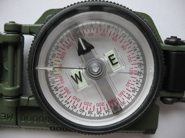
This is the face of a Cammenga brand
military prismatic compass. Cost - about 60 dollars or so. The dial
is marked in degrees with reciprocal bearing in red, the needle is
glow in the dark and as you can see, East and West are highlighted.
The outer dial is marked in one degree notches, so you can use it in
the dark - but why would you want to?
An excellent bit of kit and well worth
the money. Okay for your kit, but still a bit of overkill. What's
next?

The Silva brand "Ranger' compass.
Listed at 51 dollars on the Silva website.
Rugged, has a sighting system, can be
used to quickly orient you maps and has map scales on the base plate.
Huummm, almost prefect. This model allows you to dial in the
declination. And then?

The Silva Guide model 426 - ahhh, just
right. About 15 dollars on-line. Comes a variety of colors, and it
floats. The sighting mirror has a Vee notch at the top of the
mirror’s sight line. The compass needle itself is made out of
tungsten steel with a friction free sapphire bearing -so it moves
freely. The compass is filled with clear antistatic liquid, so no
annoying bubbles inside the dial or needle flutter. You can fold the
cover back behind the compass if you want it be out of the way, say,
while using a map. 2.5 inches square, it takes up little space. Did
I mention, it will float? The dial is divided in 2 degree
increments.
There are other compasses out there.
Well made and a quality product. I've been using Silva and Suunto
products for over 5 decades and they have never failed me. I'm
writing this, so it is my recommendation. You can make your own
choice, of course, but please take the time to compare features and
quality, and then worry about the cost. Because if your cheapo
compass fails or is inaccurate, how big a bargain is it in the end,
really?
Okay, now you have a compass - how the
heck do you use it? Books have been written on this, so I'll point
to several on-line resources and let you pick the one you find
easiest to understand.
Field Manual 3-25.26 Map Reading
and Land navigation. The Army way of using a compass. A good read
covering all the basics, and them some. Features a prismatic compass
as seen above
A series of lessons on orienteering, a
kind of race requiring navigation to precise locations. An oldie but
goodie
Easy to read illustrated guide for the
beginner or advanced field person.
Short version for folks wishing to
brush up on old skills.
The only way to be comfortable using a
compass - is to use one. Buy a map of your local area and then use
the compass that will go in your kit to navigate from point to point!
It can be a fun family activity. Try it.
Is a (brand name) compass better
then...
Some compasses are priced higher than
others. More money doesn't always better quality, but Quality does
cost. Sapphire bearings cost more than those without, and so on.
There are a number of Indian knock-offs of the Brunton Pocket Transit
made of brass that are great paperweights. I'd never count on one to
find True North.
Do I really need to orient my map?
When you are doing so-called paper
exercises, planning, measuring distances, identifying hazards like
low lying areas - no. In the field using the map to get from Point B
to Point B, I would argue that you do need to orient the map for best
results. Terrain features may look the same as another if you aren't
sure of you exact location.
I don't need a compass, I have a
GPS!
I'm happy for you. Most GPS units
offer a heading feature - acting like a compass. I know the compass
I use is accurate to + / - 1/2 of one degree. What about your GPS
unit? Good luck on finding that information for your unit. I have a
nice GPS unit and have used it when going photography overseas for
industrial operations, marking the place I captured the image in a
database and log. This is different that land navigation.
Are you saying a GPS is no good?
I am saying - be careful.
Printed maps and GPS coordinates may
not agree - some map products - mostly outside of North America
anymore, may be 'off' by upwards of several miles - the older the map
data, the more likely this is to happen. This is because some
products are using data obtained before the GPS system was in place -
I have maps based on 1950s data - the data on the map is good -
mountains haven't moved, but the geophysical coordinates don't match
up to my GPS - owing to systematic errors from back in the day.
You've heard to the stories of people
blindly following their in-car 'navigation system' and driving into
lakes, rivers or even the ocean. A map requires a bit of care and
should always be considered an aid to your travels. The older the
map, the more care should be exercised, items build by man may be
removed by nature, so any map you use to navigate from your home to a
place of refuge should be vetted.
Pick and drive your alternate routes at
least yearly. City road maps should be replaced on a regular basis,
especially if you live in or near a fast growing area. Use your maps
in advance to find choke points - bridges or overpasses/railroad
bridges that could collapse and block the roadway. Mark and know the
low lying areas that may be prone to flooding.
Thank you, Mr. Richardson, for this excellent information. We are fortunate to have you share your knowledge with us.
Please leave comments or questions below, or email them to
Susan and the Poverty Prepping team
I was just thinking about compasses yesterday. I don't have gps and might not want to count on it in an emergency if I did. Good, straight-forward post.
ReplyDeleteThanks,
Lawana
Thanks Lawana.
ReplyDeleteI'm editing the book version now - a book with lots of photos. I hope you'll find the book interesting as well.
Thanks again
DKR/dkr